Why doesn't the media provide map context?
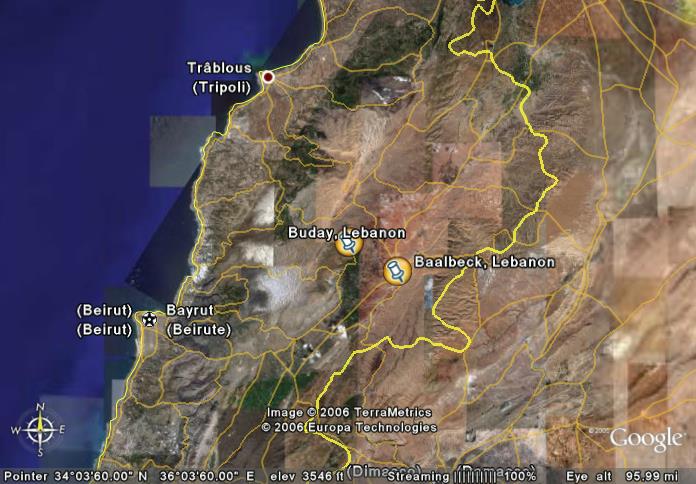
It seems like every media report from Lebanon gives general directions for the location but they don't always mean anything. For instance the latest story about the IDF raid in eastern Lebanon describes it in three versions each picked up by many news sources; 1) They landed 30km east of Baalbeck and drove east to Buday, 2) near Baalbeck in the village of Bodai, and 3) 20 km east of Buday near Baalbeck.
It took me a while to find a web source that could locate Buday, but finally on maplandia.com I did. After mapping both Buday (no Bodai found) nd Baalbeck on Google Earth using the latitude and longitude provided by maplandia I then used GE's Measure tool. Buday is 15km west of Baalbeck and Baalbeck is 10km west of Syria. So the later story was the most correct.
Only a few stories gave additional background such as;
Some say Yazbek, who is a senior member of Hezbollah's Shura consultative council and representative in Lebanon of Iran's supreme leader Ayatollah Ali Khamenei in charge of financial grants from Khamenei's office, was seen in the area as recently as Friday.
Yazbek, who is originally from Buday but does not reside in the village, was glimpsed attending the funerals of Hezbollah fighters who were killed during Israel's month long offensive in Lebanon, they say.
Really with the ease and speed of web sources there is no excuse for reporters, or at least their editor when the reporter is in the field, to not check the web for correct locations, place names and other facts.
**** So that's what an Instalanche is! Thanks Glenn! And thanks to all of you who stopped by to read my tiny little blog here. ****
*** Some noted the lack of good online maps for Lebanon. The best I could find was this though it didn't have Buday on it. One thing I did find very intesting about this detailed map were the roads shown. By the zig-zags depicted on some roads I expect some awesome mountainsides are involved. I was less than thrilled with maplandia's display ability but at least it had most sites mentioned listed with Lat/Long data. ***
posted by JB @ 12:11 AM
7 Comments
![]()
![]()

7 Comments:
The reason this isn't done is because they don't know how to do it and forget that there are a few of us who do. Besides, why let the facts get in the way of a compelling story.
I found that there were few good maps of Lebanon that gave borders to both Israel and Syria and also gave enough place names to orient stories in the news.
Because if they looked at maps they would see how small Israel is.
I and every other geography blogger agree with you!
Baalbeck -- 10 km from Syria, mmm? For the folks in Rio Linda (apologies to Rush) that is like, 6.2 miles. To put that in perspective, Manhattan is 13.4 miles long, and 2.3 miles wide. Now details like that might help make the issue a easier to grasp for Americans. But then, that's not the goal of the news, is it? It might be useful, not to mention important, to really accurately describe the situation -- and perhaps pursue the implications in the story.
Here is a priceless reflection on the true size of Lebanon and Israel
We will have every Hizbollah women fucked by dogs.
We will send Phallus of ours into ass of All priests moslems.
We will have Khamenei and Rafsanjani and Ahmadinejad and Khatami and Akbar Ganji fucked by a great penis Of donkey and whale .
We will fuck all foreign government which help mullah.
کیر سگ تو کس ننه سید اولاد پیغمبر و کس ننه خود پیامبر اسلام.
کیر خوک تو کس ننه امام حسین.
کیر خر تو کس ننه شیعیان.
صلوات: الله و کیر خر تو کس ننه محمد و آل محمد.
This is a beautiful cultural message for you.
Post a Comment
Subscribe to Post Comments [Atom]
<< Home